Research Topic
The Regional Planning and Information Laboratory develops spatial information knowledge and utilizes it in national, regional, and urban policy and planning. Spatial information refers to maps, aerial photographs, satellite images, and statistical data that can be used to adequately understand the actual conditions of nations, regions, and urban over time and space and to share this information as knowledge with many people. Therefore, spatial information is the social infrastructure supporting our daily lives and economic activities.
The situation surrounding spatial information keeps changing due to the development of an advanced information society. With the advances in communication technology and the widespread use of mobile devices, significant progress can be seen in spatial information and surveillance technologies, such as geographic information systems (GIS), image processing, global navigation satellite system (GNSS), remote sensing, and laser measurement. For example, location data can be obtained semi-automatically and managed efficiently. Statistical and mapping data has also been digitalized and is available for free or inexpensively.<\p>
Various types of information that are expanding and refining spatially or temporally can be summarized on the basis of space and time location information. This summarized information can be applied to a planning theory linked to real space. Moreover, ideas can be shared with many people by combining data and analyzing and expressing it in various ways. Further advancement of analysis can be expected by integrating simulation and other technologies. Solid methodologies like statistics and history are fundamental for conducting such a study.
Thus, an information environment is now in place to interpret and discuss the history and current status of national lands, regions, and cities, as well as what they are and should be in the future, from a new perspective that is not bound by conventional ideas. Spatial informatics is an interdisciplinary research field that integrates arts and sciences and is concerned with maintaining, managing, representing, analyzing, and utilizing spatial information. We want to position these spatial informatics as a new axis for fostering awareness of issues, constructive discussion and consensus building, and policy decision-making for national, regional, and urban planning.
Recent research themes are listed below.
Dissertations and theses by students can be accessed from here (in Japanese) . To know about the research works by faculty members, please click here.
Integration of Diverse Data
Integration of Vector and Raster Data / Data by Range Sensors
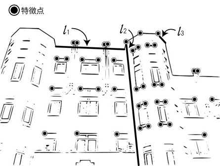
Thanks to the development of sensing technology, a wide variety of observation data has become available. As a result, it is getting more important to analyze not only from single data but also by integrating diverse data. For example, we are developing a method to measure a target space by combining various data from mobile devices, including images and location, distance, and angle information. We are also developing new methodologies for integrated analysis of multiple types of measurement information.
Integration of Simulation and Data
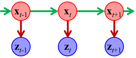
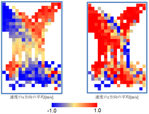
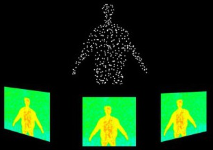
General State Space Model / Analysis of Pedestiran Velocity
In recent years, sensing and simulation technologies have been remarkable developments. New discoveries can be expected by analyzing findings that cannot be obtained from data alone, together with simulations. Thus, we are researching to integrate data and simulation and apply them to monitoring space and time. For example, using both models to predict human movements and data from observations of human positions will open up possibilities for unprecedented plans.
Inference of Structure from Data and Its Visualization
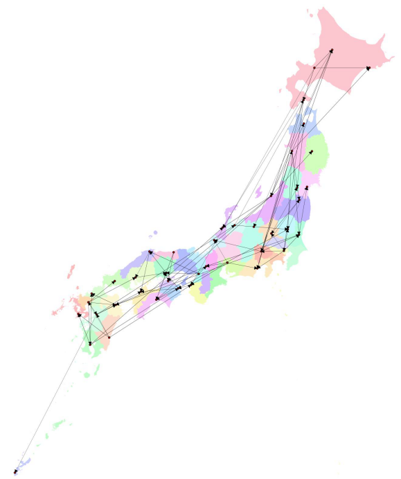
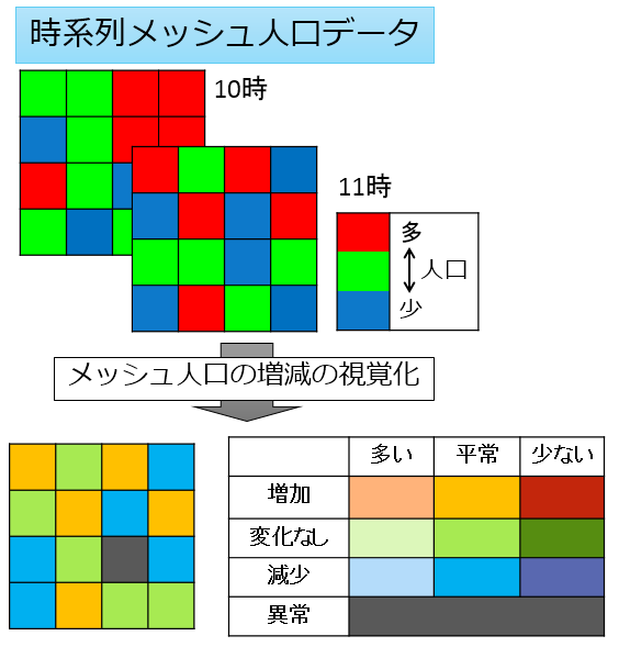
Interdependency of Prefectures in Japan / Anomaly Detection by Spatio-Temporal Population Data
With the advancement of sensing technology, it has become possible to observe phenomena occurring in the real world as a wide variety of data. However, observed data does not tell us why the phenomenon is happening or why the data is generated. Therefore, we are researching the mechanisms that give rise to fundamental phenomena and data, using the observed data as clues. We also examine methods to visualize the means so everyone can understand them easily.