8/5 (火) から8/7 (木) の3日間で学部3年生を対象にした空間情報学実習が開催されました。今年は例年よりも厳しく、最高気温が39℃に迫る酷暑の中、日本測量協会と千代田測器の方々にご協力いただき、学部3年生26人が5班体制で実習に取り組みました。
1日目は水準測量、2日目は多角測量を行い、3日目はRTKや三次元復元などの最新技術のデモンストレーションが行われました。
各班の水準測量、多角測量の閉合差と許容誤差は以下の表の通りとなりました。
| 1班 | 2班 | 3班 | 4班 | 5班 | |
| 水準測量閉合差 (mm) | 4.0 | 10.0 | 11.0 | 21.0 | 6.0 |
| 水準測量許容誤差 (mm) | 18.2 | 18.2 | 19.4 | 19.4 | 15.0 |
| 多角測量閉合差 (mm) | 29.0 | 182.7 | 142.6 | 186.4 | 67.1 |
| 多角測量許容誤差 (mm) | 187.6 | 187.6 | 192.5 | 192.5 | 175.5 |


実習に先立ち、地情研メンバーでiPadのLiDARスキャナーを利用して、三四郎池の点群スキャンを行いました。点群データは衛星測位(ネットワークRTK)によって地図上の絶対座標が定まりますが、電波状況の悪い三四郎池では数m単位の誤差が生じてしまいます。


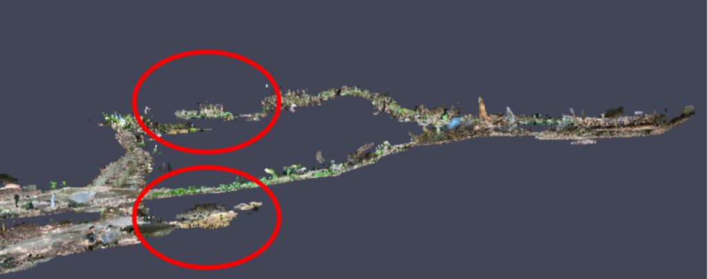
そこで、実習内の水準測量・多角測量によって得られた各点の座標値を用いて、点群データを補正しました。段差だらけでバラバラだった点群データが、補正を行うときれいに繋ぎ合わさり、測量の意義をわかりやすく実感できるものとなりました。

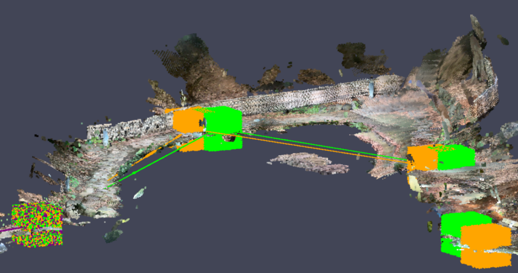
また、水中を撮影できる水中ドローンを用いて三四郎池の水中を研究室メンバーで撮影し、水中の構造物の3次元復元を試みました。水中ドローンの操作の難しさや三四郎池の水質の悪さなどにより、満足のいく復元はできませんでしたが、実習参加者の皆さんに測量の幅広さを実感してもらえたのではないかと思います。


3日目の演習後には、教室を利用して打ち上げが開催されました。午後3時半ごろから始まり、午後7時ごろまでお菓子や飲み物を囲んで談笑しました。本研究室の教員・学生と演習に参加したB3の学生に加え、交通研のB4の学生にも参加していただき、終始和やかな雰囲気に包まれました。B3の学生からは研究室生活や研究室選びに関する質問も寄せられ、学生らが経験を踏まえて丁寧に答えていました。今回の打ち上げは、学年間や異なる研究室間のつながりが一層深まる貴重な機会となりました。
From August 5 (Tue) to August 7 (Thu), Geoinformatics Project was held for third-year undergraduate students. This year was more challenging than usual, with the temperature soaring close to 39°C, as 26 third-year undergraduate students worked in five groups throughout the project.
On the first day, they conducted leveling surveys, on the second day traverse surveys, and on the third day demonstrations of the latest technologies such as RTK and 3D reconstruction.
Before the Geoinformatics Project, members of Regional Planning and Information Laboratory used the LiDAR scanner on an iPad to scan the point cloud of Sanshiro Pond. While the point cloud data could be assigned absolute coordinates on a map via satellite positioning (network RTK), poor radio conditions at Sanshiro Pond resulted in errors on the order of several meters.
To address this, the coordinate values of each point obtained from leveling and traverse surveys during the project were used to correct the point cloud data. This correction transformed the point cloud—initially fragmented and misaligned due to height differences—into a neatly connected dataset, clearly demonstrating the value of surveying.
In addition, members of this laboratory used an underwater drone to capture footage beneath the surface of Sanshiro Pond in an attempt to reconstruct 3D models of underwater structures. Due to the difficulty of operating the underwater drone and the poor water quality, a satisfactory reconstruction was not achieved. Nevertheless, it gave participants a broader sense of the possibilities of surveying.
After the exercises on the third day, a social gathering was held in a classroom. Starting around 3:30 p.m. and lasting until about 7:00 p.m., participants enjoyed snacks and drinks in a relaxed atmosphere. In addition to this laboratory’s faculty and students and the third-year undergraduate participants, fourth-year students from the Transportation Laboratory also joined. Third-year students asked questions about laboratory life and choosing a lab, and the senior students responded thoughtfully based on their own experiences. This gathering proved to be a valuable opportunity to strengthen connections both between year levels and across different laboratories.
投稿者 (poster)|嶋野 (Shimano) 、武田 (Takeda) 、井野 (Ino) 、上野 (Ueno) 、中尾(Nakao)