On Tuesday, September 30, we held a welcome event for second-year undergraduates who have been newly admitted to the Department of Civil Engineering. In our laboratory, we introduced our research. After the overview, we took questions and chatted about life in civil engineering and how to choose a lab, and we wrapped up with a short hands-on demo of stereoscopic (3D) viewing. To all B2 students: we hope you’ll enjoy many lectures and practical exercises in a new environment at Hongo Campus and in the Department of Civil Engineering!
On September 17th, the midterm review of thesis was held, and three B4 members in this lab gave presentations. Below are the titles of their research.
Ino “Detecting Urban Change through Cross-Modal Contrastive Learning of Satellite Images and Social Statistics”
Ueno “An Influence Analysis for the Progress Rate of Cadastral Survey in Japan based on an Analysis of White Paper for Land and Progress Rate Data”
Nakao “High-Resolution Enhancement of 3D Point Cloud Data from Mobile Device LiDAR and Task Performance Evaluation”
I was nervous since it was the first time for us to present our research to those who are not the lab members, but we all completed the presentation successfully! Also we were able to get valuable comments from professors and students in other labs. We will make progress in our research utilizing the result in this review!
From August 5 (Tue) to August 7 (Thu), Geoinformatics Project was held for third-year undergraduate students. This year was more challenging than usual, with the temperature soaring close to 39°C, as 26 third-year undergraduate students worked in five groups throughout the project. On the first day, they conducted leveling surveys, on the second day traverse surveys, and on the third day demonstrations of the latest technologies such as RTK and 3D reconstruction.
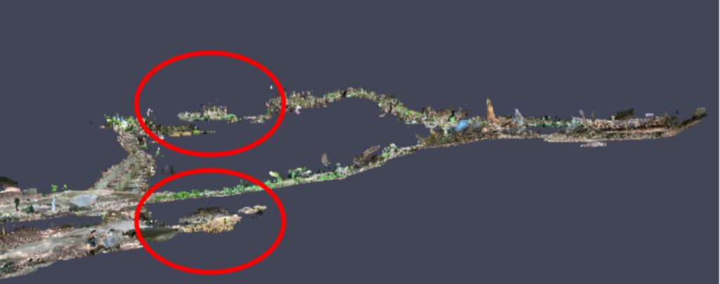
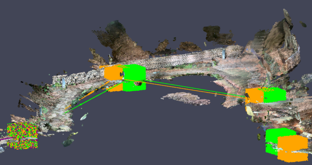
Before the Geoinformatics Project, members of Regional Planning and Information Laboratory used the LiDAR scanner on an iPad to scan the point cloud of Sanshiro Pond. While the point cloud data could be assigned absolute coordinates on a map via satellite positioning (network RTK), poor radio conditions at Sanshiro Pond resulted in errors on the order of several meters. To address this, the coordinate values of each point obtained from leveling and traverse surveys during the project were used to correct the point cloud data. This correction transformed the point cloud—initially fragmented and misaligned due to height differences—into a neatly connected dataset, clearly demonstrating the value of surveying.
In addition, members of this laboratory used an underwater drone to capture footage beneath the surface of Sanshiro Pond in an attempt to reconstruct 3D models of underwater structures. Due to the difficulty of operating the underwater drone and the poor water quality, a satisfactory reconstruction was not achieved. Nevertheless, it gave participants a broader sense of the possibilities of surveying.
After the exercises on the third day, a social gathering was held in a classroom. Starting around 3:30 p.m. and lasting until about 7:00 p.m., participants enjoyed snacks and drinks in a relaxed atmosphere. In addition to this laboratory’s faculty and students and the third-year undergraduate participants, fourth-year students from the Transportation Laboratory also joined. Third-year students asked questions about laboratory life and choosing a lab, and the senior students responded thoughtfully based on their own experiences. This gathering proved to be a valuable opportunity to strengthen connections both between year levels and across different laboratories.
The Lab seminar was held on August 1st. In the seminar, forth-year students presented their research. I was so nervous since it was the first time for us to present our research to the lab members, but we were able to get important comments! We will make progress in our research taking in the comments.
Below are the titles of the research.
Ino “Development of a Base Model Integrating Satellite Images, Location Coordinates, and Demographic Statistics”
Nakao “High-density LIDAR Point Clouds Combining Sparse Modeling and Diffusion Models”
Ueno “An Influence Analysis for Cadastral Survey in Japan based on an Analysis of White Paper for Land using Topic Modeling”
The lab seminar was held on Monday, August 4th, where second-year master’s students and doctoral students presented their research. The seminar was a long session featuring progress reports from a total of five presenters: Shimoda-kun, Peng-kun, Shimano (me), Sakaban-san, and Morota-san, in that order. We received a variety of valuable feedback from our lab members, which we hope to incorporate to further improve our research moving forward.
Below are the titles of the presentations.
Shimoda “Development of a Map Updating Method by Integrating Multi-Resolution Images” Peng “Few Approaches to Realize Geospatial Understandable Spatial-Temporal Agent” Shimano “Construction of a Feature-Independent Underwater Photogrammetry Method in Shallow Waters” Sakaban “Development of a General Domain Adaptation Method under Complex Domain Shifts in Satellite Imagery” Morota “Method for Generating Current Road Condition Maps for Road Management through Joint Learning of LiDAR Point Clouds and Camera Images”